Environmental land monitoring
Environmental land monitoring
The main source of today’s environmental changes is human activity. Expanding cities, transport networks and industries often occupy valuable agricultural and forestry land. More and more land is being cultivated to meet the growing food demands of the population, which involves deforestation and drainage of swamps. All these activities result in a steady decline in the habitat of natural flora and fauna and, in the long term, also have a negative impact on human living conditions.
The aim of environmental management is to apply long term, cost effective, environmentally friendly solutions beyond the exploitation of natural resources that provide short term financial benefits. It requires thorough planning, which demands models that can predict the impact of decisions. Land cover data, that can be prepared for a large area on the basis of satellite images, supplies reliable information for these studies and, furthermore, provides an opportunity to monitor the effects of our activities and decisions.
European land monitoring
The main tasks of the Land Monitoring Unit are related to national and European land monitoring services. Since 2001, our experts have continuously participated in activities of the land cover related European Topic Centres, which form part of the background institution network of the European Environment Agency (EEA):
- 2001-2006: European Topic Centre - Terrestrial Environment (ETC-TE)
- 2006-2010: European Topic Centre - Land Use and Spatial Information (ETC-LUSI)
- 2011-2014: European Topic Centre - Spatial Information and Analysis (ETC-SIA)
- 2015-2021: European Topic Centre - Urban, Land and Soil Systems (ETC-ULS)
As core member of the consortium forming the Topic Centres, we play a key role in the technical coordination of the preparation - including development of methodologies, compilation of guidelines, training the experts of the participating 39 countries - and the quality control (verification) of the pan-European land cover databases. As members of the Topic Centres, activities also include development and testing of land cover related functional applications and indicators, analysing datasets and methodological developments, by participating in:
- elaboration of INSPIRE land cover data specification,
- preparation, technical coordination and validation of pan- European databases of the COPERNICUS program covering 39 countries, such as CORINE Land Cover databases and Copernicus High Resolution Layers, including the development of CLC2018 Support Package software,
- validation of Copernicus local component databases, such as Urban Atlas,
- analyses based on the above-mentioned databases, testing of Urban sprawl and High Nature Value indicators, developing Land take and Imperviousness change indicators.
Besides the above described tasks, our experts participate in long-term strategic development, actively contributing to the improvement of the European land monitoring concept (FP7 HELM project) and the elaboration of a common European land cover data model within EAGLE (Eionet Action Group on Land Monitoring in Europe) working team. The EAGLE model may serve in the future as a core element of the European land monitoring framework (CLC+), supporting “bottom-up” collection of land related information.
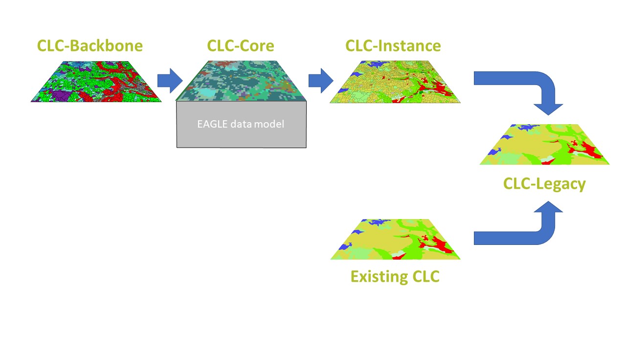
Scheme of CLC+ concept
A significant part of the above mentioned land monitoring activities is carried out under the European Copernicus program. As a member country of the EEA, we prepared the Hungarian CORINE Land Cover data for reference year 2018 (CLC2018) and the CLC change 2012-2018 database and continue to verify the High Resolution Layers for the territory of Hungary.
European CORINE Land Cover data: The time series of the European land cover mapping program launched in the mid-1980s was expanded to 5 elements with the status layer of reference year 2018 (CLC1990, CLC2000, CLC2006, CLC2012, CLC2018) with a Minimum Mapping Unit (MMU) of 25 hectares. A land cover change map has also been produced for 2012-2018 with a Minimum Mapping Unit (MMU) of 5 hectares. It consists of an inventory of land cover in 44 classes. The database is created for the territory of Hungary by visual interpretation of satellite images, meeting strict quality requirements. (Based on the CORINE database, the Hungarian land cover profile in 2012 (Country sketch. Land cover 2012 for Hungary]) the Hungarian language version can be downloaded from here.)
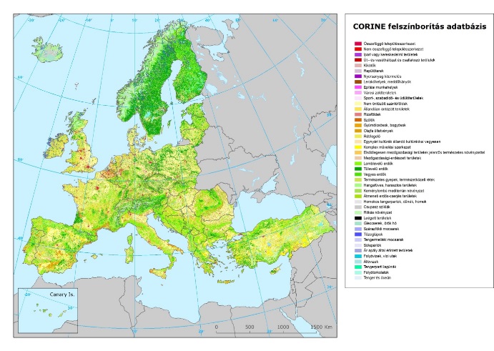
Land cover map of Europe (CORINE Land Cover database)
Copernicus High Resolution Layers (HRLs): In the frame of the Copernicus Land program five High Resolution Layers covering all Europe:
- Imperviousness (soil sealing %),
- Forest (Tree Cover Density % and Dominant Leaf Type),
- Grassland,
- Water and wetness,
- Small Woody Features
The databases produced by European service providers, the quality control, corrections and data dissemination for Hungarian datasets are performed by Lechner Knowledge Center.
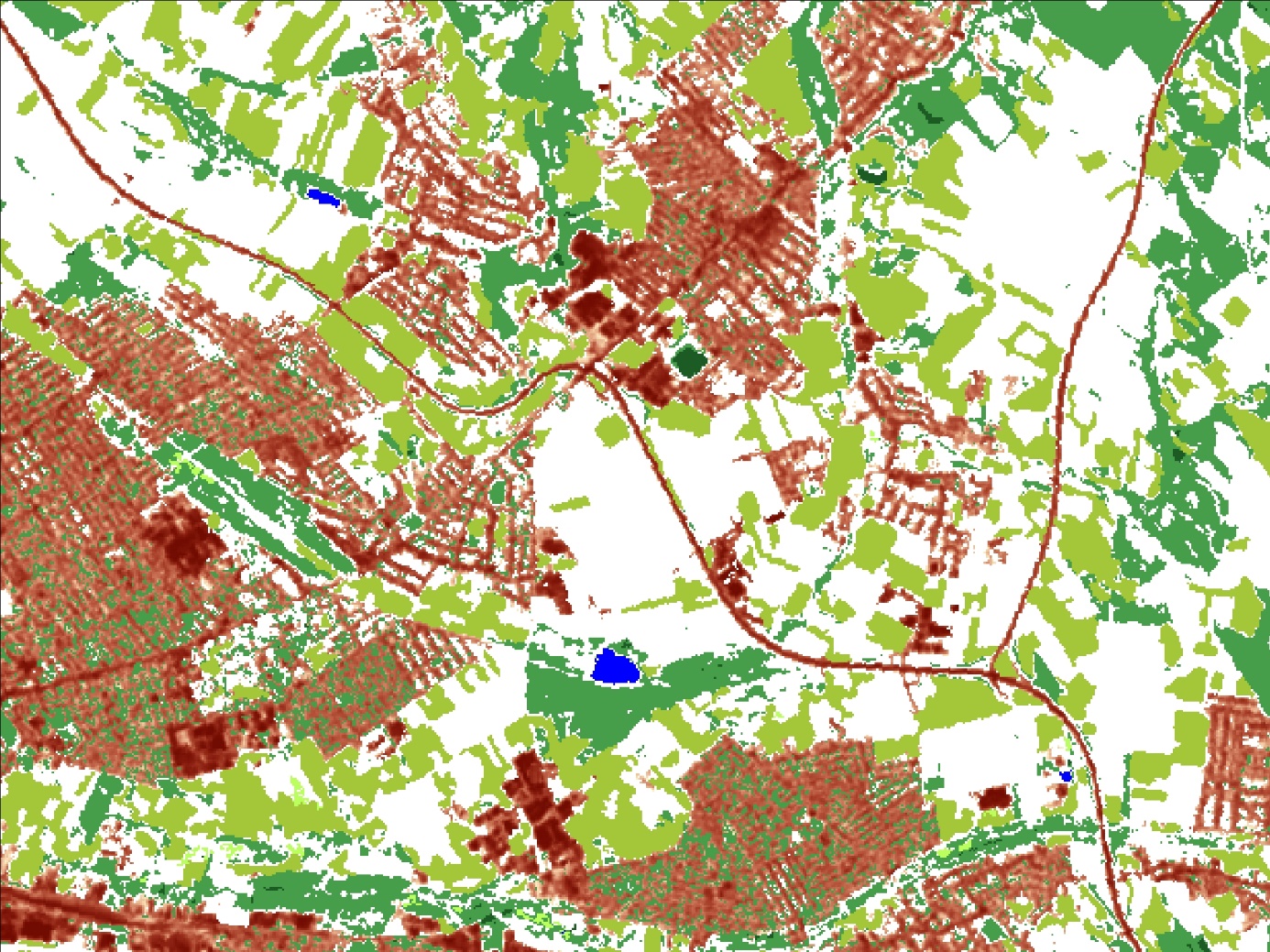
Land cover map of Budapest – Csömör – Nagytarcsa area ((High Resolution Layers, 2015)
National CORINE Land Cover data (CLC50)
In response to national user needs and to support Hungary’s accession to the European Union, the Ministry of Agriculture and Regional Development initiated the national CLC mapping project at scale 1:50.000 (CLC50) within the frames of the Acquis National Programme in 1996. For the nomenclature of this national survey the standard (level-3) CLC nomenclature is enhanced to include nearly 80 classes on level-4/5. The 4 hectare minimum mapping unit (1 ha for water) provides enhanced geometric detail. The database was prepared to cover the period of 1998-99 and has not been updated since then. Further information on the preparation of the CLC50 database and its parameters can be found HERE.
Data dissemination
Results of Copernicus projects for the territory of Hungary (CLC2018, High Resolution Layers, Urban Atlas, Riparian Zones and NATURA 2000 land cover databases) in the Hungarian national projection (EOV) and the Hungarian National CLC50 database are freely downloadable from the homepage of Lechner Knowledge Center.
Contacts
Dr. Lehoczki Róbert, Land Monitoring Unit,
telephone: +36-1-460-4278
E-mail: robert.lehoczki@lechnerkozpont.hu
Maucha Gergely, Land Monitoring Unit,
telephone: +36-1-460-4177
Email: gergely.maucha@lechnerkozpont.hu