Remote Sensing
The Remote Sensing Department and the Earth Observation Unit has decades of research, development and operational experience in the processing, analysis and use of satellite imagery, through the former Institute of Geodesy, Cartography and Remote Sensing (FÖMI), a predecessor institution of the Lechner Knowledge Centre (LTK). The experiences are dated back to 1980 when the FÖMI Remote Sensing Centre was established and started its operation as a national centre.
Today, thousands of satellite images of the Earth's surface are taken every day, and many of these are freely available and usable. As a result, the information derived from satellite images plays a huge role both in research on global issues such as climate change and its impacts and in operational use at national or regional level in different disciplines. Today, the increasing spatial and spectral resolution of sensors can provide a good basis for local research also.
Our primary activities include the development of methodologies for various mapping purposes, the downloading and pre-processing of optical and radar satellite images, the compilation, interpretation and analysis of satellite image time series. This last phase is also one of the main research and development activities of the Unit, where new machine learning algorithms are tested and processing is automated to the highest possible degree. Thus we can facilitate a faster response to ad hoc tasks and an increasingly efficient performance of operational tasks. Automatization is necessary, as there are years when a flood or inland water situation has to be mapped within days at the national level, or, unfortunately, more and more often, a drought damage assessment needs to be carried out at the country level. Our current tasks are varied. We produce maps to support the monitoring activities of the Common Agricultural Policy, and we work with other departments of our institute on tasks requiring remote sensing techniques for various national and international projects We regularly publish the results at national and international conferences..
The Earth Observation Unit mainly uses data from the Sentinel satellite constellation established and operated by the European Union and the European Space Agency (ESA) under the Copernicus programme, but this may vary depending on the task. New and archive images from NASA's Earth observation satellites are also used, especially images from Aqua, Terra and the Landsat series. These satellites provide a great basis for long-term monitoring of changes on the Earth's surface.
Our Unit also plays an active role in awareness-raising and education.
In Hungary, the Lechner Knowledge Centre operates as a professional background institution of the Prime Minister's Office.
The institute focuses its activities in collecting, acquiring, processing and analysing remotely sensed data and country-wide thematic mapping, along with research and development in a variety of application fields, for public administration development and support mainly – in cooperation with the Ministry of Foreign Affairs and Trade. The institute also plays a central role in the coordination and quality control of European land cover mapping activities, provides training for experts from the 39 participating states and contributes to strategic developments shaping the future of this field.
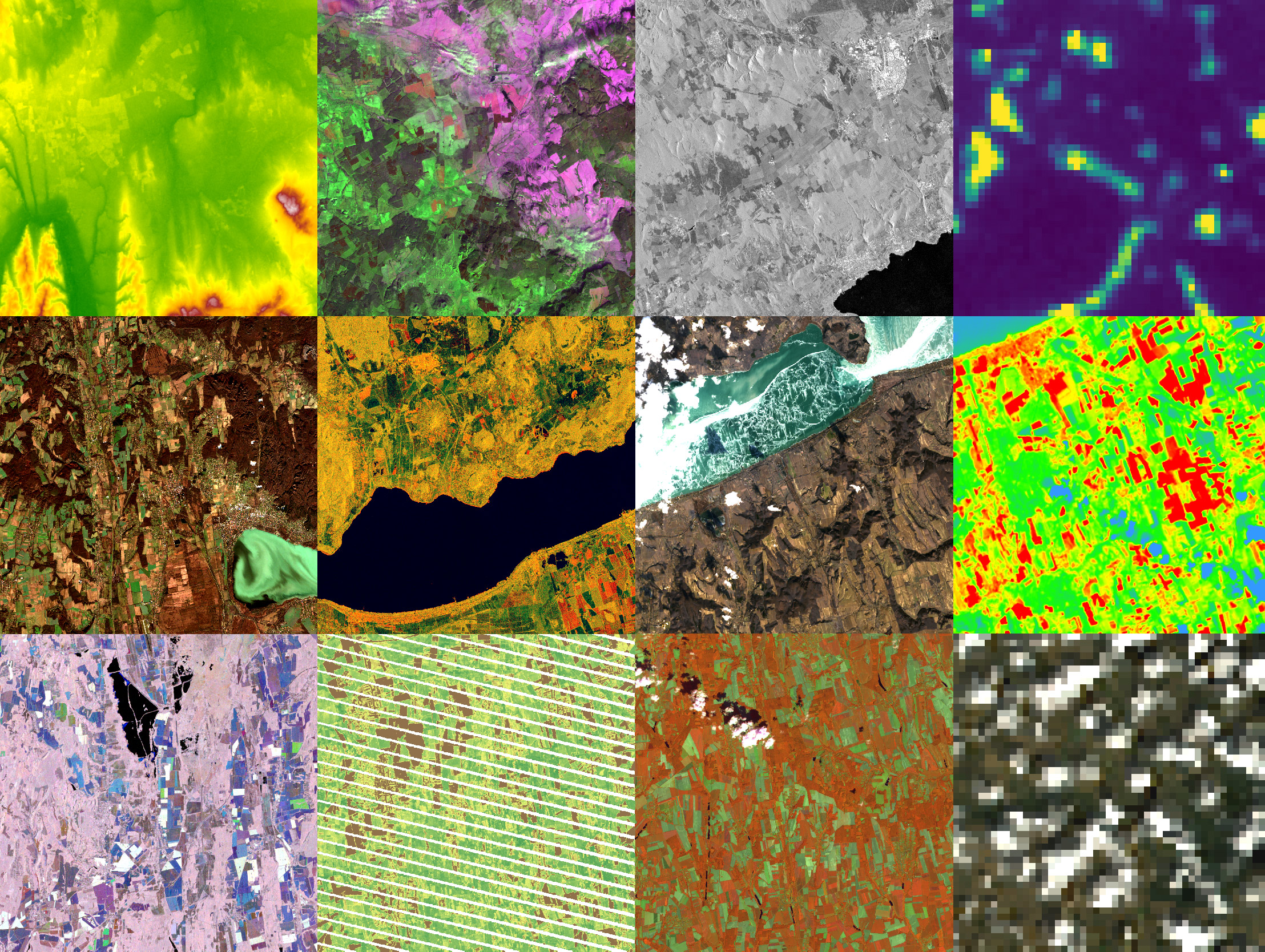
In addition to being able to take images of a very large area at a time, satellite sensors are also able to produce images using wavelengths that are invisible to the human eye. These wavelengths carry very important information about objects on the surface. Processing software and algorithms can process this information and also assign colours to these wavelength ranges so that the images can be visually interpreted also.
Besides mapping the state of objects, features and phenomena on the Earth surfaces, there is a growing emphasis on detecting and mapping changes in the last decades. Image processing and analysis algorithms have evolved very rapidly in recent decades, so they can meet the needs: the analysis and processing of long satellite image time series is no longer a problem. Currently, our department is working with such algorithms.
![]()
Our main research focus is on the integrated processing and analysis of time series of optical and radar satellite images, the monitoring of the state and change of the Earth's surface and the automation of all these workflows to the highest possible degree. In addition, of course, the integration of human expertise and experience in the analysis is key. Methodologies are being improved constantly to enhance the mapping accuracy, develop new solutions and reduce dependence on reference data. We use machine learning algorithms in addition to the "traditional" classification methods and strive for continuous improvement, learning and applying the latest algorithms and technologies. For research and development tasks, we mainly use satellite imagery that can be downloaded free of charge from ESA (European Space Agency) and USGS (United States Geological Survey) databases, as well as from Google Earth Engine (GEE) cloud services. Occasionally processing is also done in the GEE environment.
In recent years, there has been a clear increase in the frequency and duration of weather anomalies, which is not surprising in the context of climate change (IPCC, 2012). In addition to the regular production of national drought maps related to this topic, we also strive to study new satellites monitoring climate change, to solve the new challenges in the processing chain thus ensuring a long time series of satellite data.
In addition to pixel-based image processing methods, object-based image analysis (OBIA) is also used in many tasks.
The results of our R&D activities are directly fed into the current projects and operational tasks. Current tasks of the department:
- Providing data on demand to government actors, e.g. government agencies and offices.
- We are actively involved in the development of the Earth Observation Information System (FIR) to support government tasks with integrated remote sensing.
- Providing data for the National Land Center (NFK) operationally for agricultural administration purposes to support area-based payments (map of permanent grasslands, production of auxiliary coverages for the new type of monitoring system).
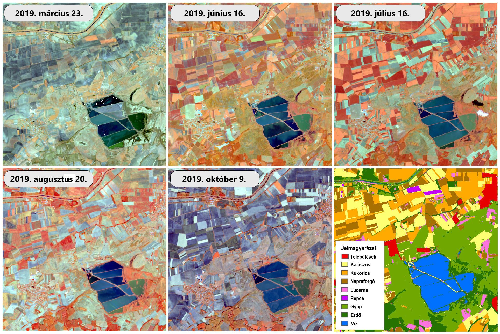
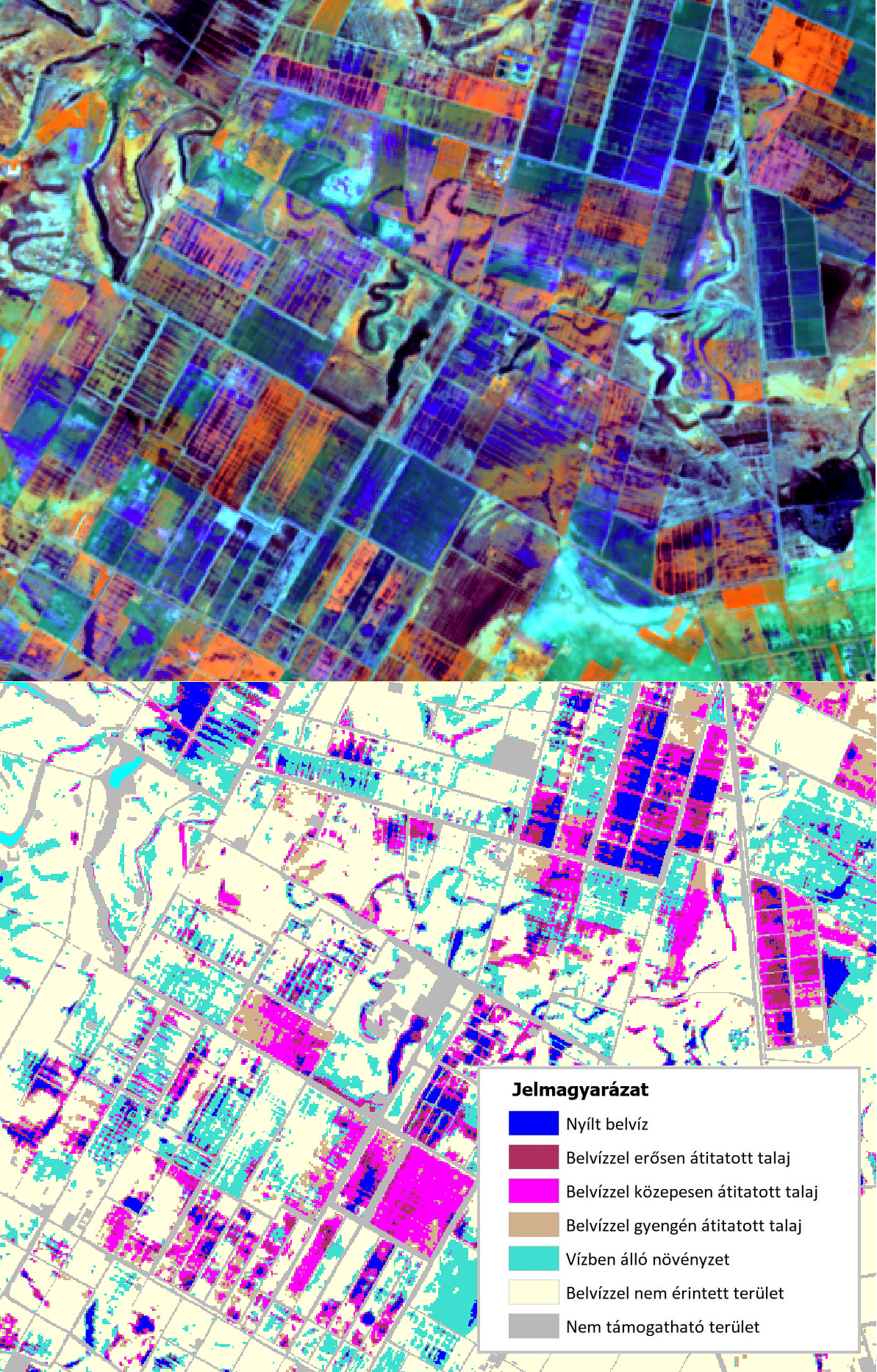
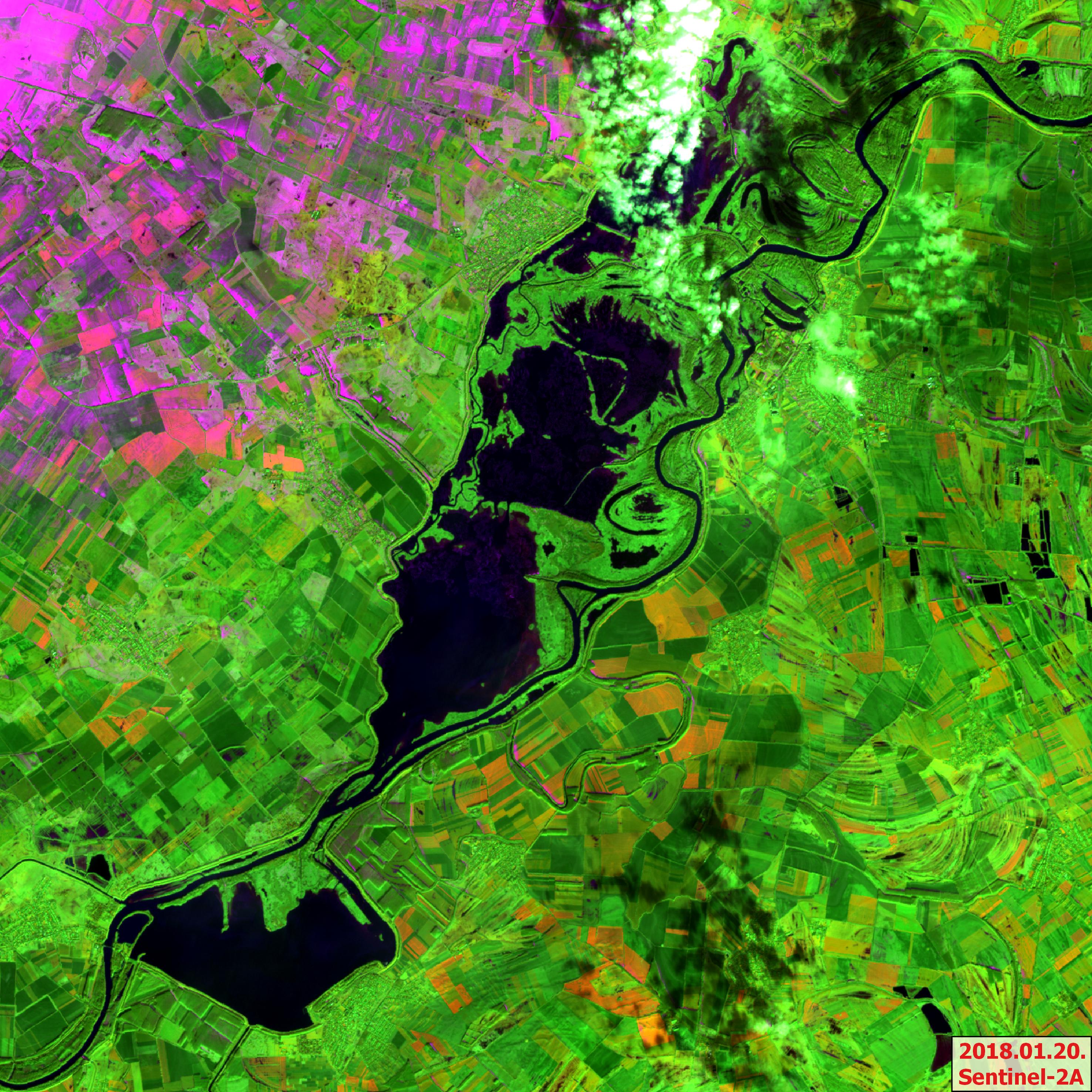
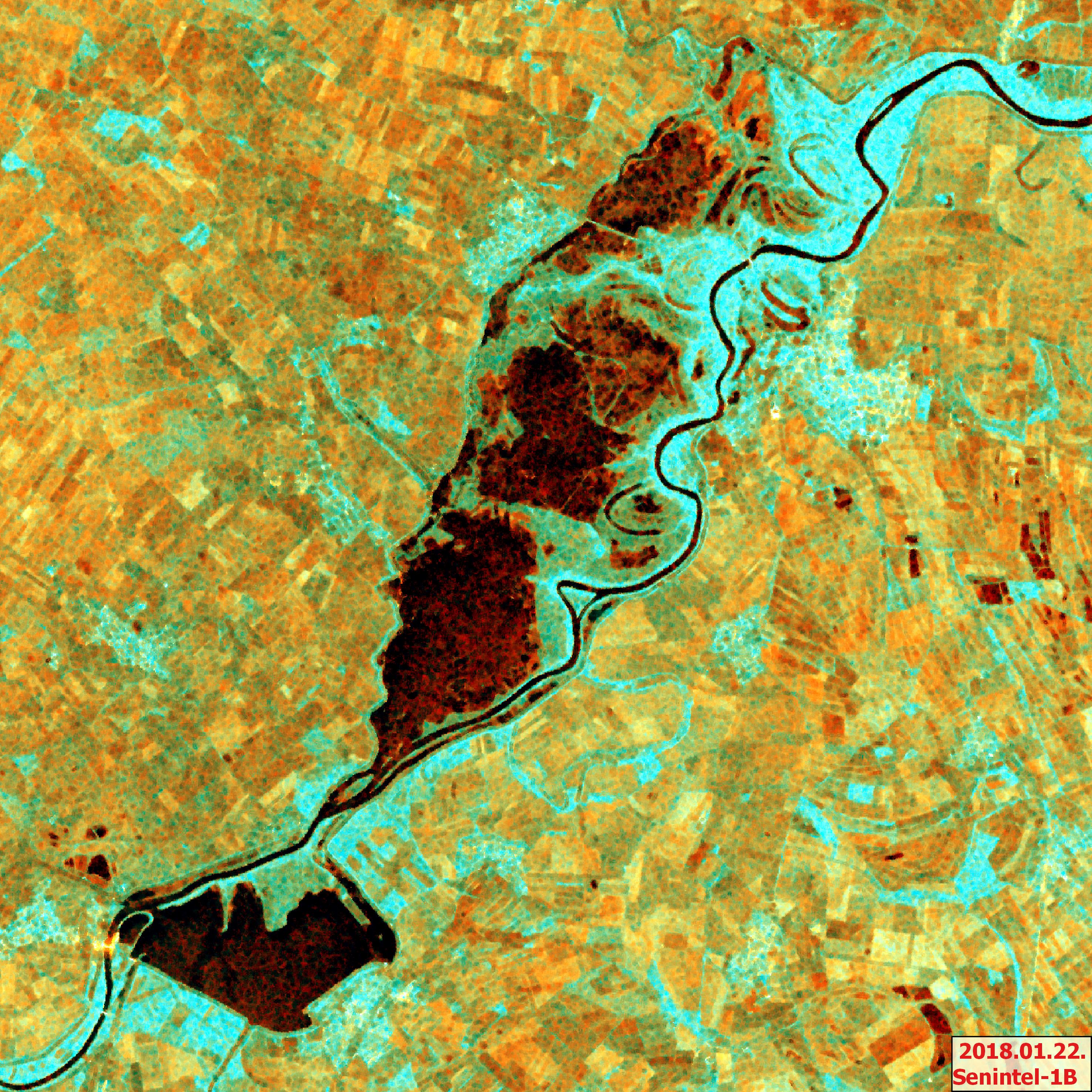
- Production of inland water, flood and drought maps, vegetation and other indices for the Agricultural Risk Management System (MKR) to support the verification of damage reports. An interesting feature of our remote sensing-based drought maps is that instead of weather parameters they are based on the changes in spectral values dependent on vegetation conditions derived from satellite images. In this way, it is possible to detect how vegetation reacts to - or is damaged by - extreme weather conditions. Our baseline database for the inland water frequency map dates back to 1998.
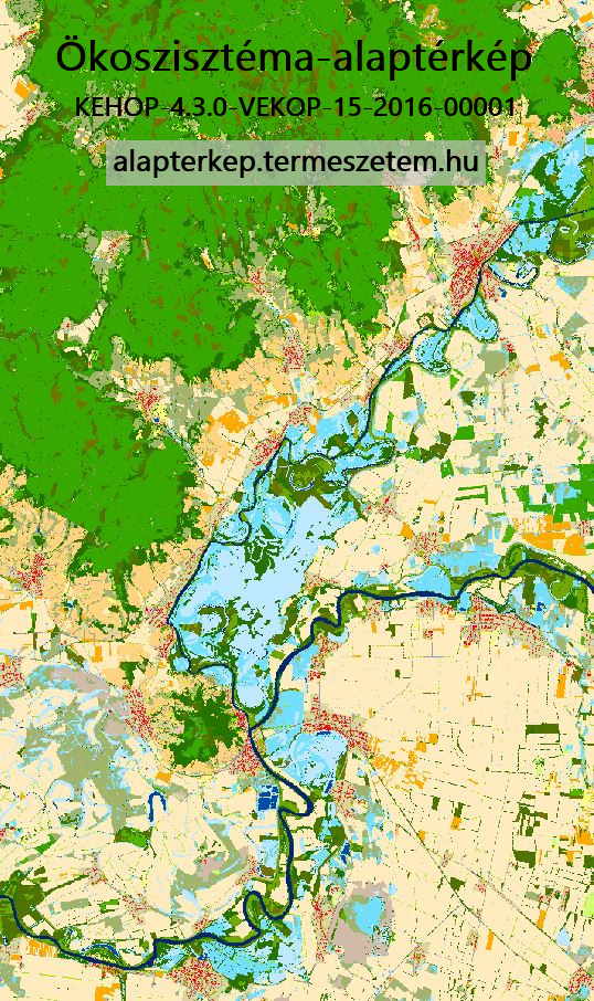
- Together with other departments of the Lechner Knowledge Centre, we played a major role in the production of the Ecosystem Map of Hungary.
In addition, we also undertake case-by-case problem solving, where backtracking or documented investigation using remotely sensed data can help in a specific case that cannot be clarified in any other way. For example, we regularly provide expert opinions based on image analysis for litigation related to land use, agricultural cultivation, based on court or personal request.
The Earth Observation Unit is involved in the following projects in cooperation with other departments of LTK:
| Projekt | Megvalósítás időtartama |
|---|---|
|
Complex Agricultural Risk Management System EKOP-1.1.12-2012-2013-0001 |
April 2013 - June 2014 (under development) June 2014 - (implementation) |
|
Development of the Agricultural Water Use Information and Control Framework KÖFOP-1.0.0-VEKOP-15-2016-00023 |
1 October 2015 - 31 December 2021 |
|
Strategic assessments supporting the long-term conservation of natural values of Community interest as well as the national implementation of the EU Biodiversity Strategy to 2020.
NÖSZTÉP project element. KEHOP-4.3.0-VEKOP-15-2016-00001 |
1 October 2017 - 31 October 2021. |
|
Development of Earth Observation Information System (FIR) Earth Observation Data Infrastructure and Services KÖFOP-1.0.0-VEKOP-15-2017-00050 |
1 January 2018 - 30 September 2021. |
In addition to participating in operational national data production, research and development, our team also covers important environmental and/or land cover-related events occasionally that are currently leading news in the media and can be illustrated by remote sensing (in Hungarian). Such events have included the 2019 Siberian forest fire , or China's emissions decline caused by the coronavirus epidemic, but also the tracking of the huge volcanic pumice island from Tonga via satellite imagery. In addition to serious issues, we also feature colourful news, such as a "space flower bouquet" in 2020. For those interested in remote sensing, we recommend our news (in Hungarian), where you can narrow down your search by using the tag "remote sensing". Visitors also find here all the latest information offered by Lechner Knowledge Centre related to several fields of remote sensing applications (e.g. aerial remote sensing, cosmic geodesy, fentrol.hu, training courses, summaries of conferences, etc.).
The LTK also reaches out to younger generations. We have already performed at career guidance events – "invitation to remote sensing career” – in secondary schools, and delivered awareness-raising lectures in primary schools.
Some of our colleagues participate in university education as a lecturer or a guest speaker.
Every year, we receive graduate students (ELTE, BME, SZIE). They usually spend their internship with us to write their thesis or TDK thesis. Our colleagues doing their PhD studies receive professional assistance in the subject of remote sensing.

Tanács, E., Belényesi, M., Lehoczki, R., Pataki, R., Petrik, O., Standovár, T., Pásztor, L., Laborczi, A., Szatmári, G., Molnár, Zs., Bede-Fazekas, Á., Somodi, I., Kristóf, D., Kovács-Hostyánszki, A., Török, K., Kisné Fodor, L., Zsembery, Z., Friedl, Z. and Maucha, G. (2021): Compiling a high-resolution country-level ecosystem map to support environmental policy: methodological challenges and solutions from Hungary. Geocarto International. DOI
Zoltán, L., Friedl, Z., Pacskó, V., Orbán, I., Tanács, E., Magyar, B., Kristóf, D. and Standovár, T. (2021): Application of Sentinel-1 radar data for mapping ice disturbance in a forested area. European Journal of Remote Sensing 54(1):568–587. DOI
Belényesi, M., Birinyi E., Kristóf, D., Mikus, G., Komolafe, R. I., Rotterné Kulcsár, A., Pacskó, V., Friedl, Z., Sik, A. (2021): A Föld a világűrből. In Simon Tamás(szerk.) Magyarország és a világűr MANT, MCC Press Kft. Budapest, pp. 87-101. ISBN: 978-963-7367-27-4 Link
Birinyi, E., Kristóf, D., Barcza, Z. and Kern, A. (2021): Vegetációs indexek és meteorológiai tényezők idősorainak aszálydetektálási célú vizsgálata különböző hazai termőtájakon, kukorica haszonnövényre. Térinformatikai Konferencia és Szakkiállítás, Debrecen, 2021, pp. 67-68. Link
Zoltán, L., Friedl, Z., Székely, B., Pacskó, V., Orbán, I., Tanács, E., Magyar, B., Kristóf D. and Standovár T. (2021): Mapping catastrophic ice damage in forested area: a case study for a deciduous forest in Hungary. European, Geosciences Union General Assembly EGU General Assembly 2021: Conference Abstracts Göttingen, Németország. Paper: EGU21-10719. DOI
Zoltán, L., Friedl, Z., Székely, B., Pacskó, V., Orbán, I., Tanács, E., Magyar, B., Kristóf D. and Standovár T. (2021): Sentinel-1 radarfelvételek felhasználása jégtörés-térképezés során. 12. Magyar Ökológus Kongresszus, 2021 Augusztus 24-26. Vác. Link
Friedl, Z., Zoltán, L., Orbán, I., Tanács, E., Standovár, T. and Kristóf D. (2019): Sentinel-1 adatok felhasználási lehetőségei a jégkárral érintett erdőállományok vizsgálataiban. Fény-Tér-Kép Konferencia, 2019 (előadás) Link
Birinyi Edina (2019): Távérzékeléses nyomozás Google Earth Engine-nel. Fény-Tér-Kép Konferencia, 2019 (előadás) Link
Kristóf, D., Petrik, O., Pataki, R., Lehoczki, R., Belényesi, M., Friedl, Z., Nádor, G., Hubik, I., Rotterné Kulcsár, A., Birinyi, E., Pacskó, V., Maucha, G. and Mikus, G., (2019): Combined use of EO imagery and in situ data for country-wide land cover mapping and monitoring for various applications in Hungary: Status and perspectives. Proceedings of the ESA Living Planet Symposium, Milan, Italy, May 13–17, 2019. Link
Pacskó, V., Petrik, O., Friedl, Z., Nádor, G., Kristóf, D., Belényesi, M., Molnár, G. (2019): A wetland mapping method by temporal integrals derived from H/A/alpha decomposition of Sentinel-1 image. In: Magyar, Geofizikusok Egyesülete; Magyarhoni, Földtani Társulat (szerk.) L. Ifjú Szakemberek Ankétja, pp. 17-18., 2 p. Link
Friedl, Z., Nádor, G., Molnár, A., Surek, Gy. (2019): Crop yield estimation by Sentinel-1 radar polarimetric data. ESA PolinSAR 2019. 28 January – 1 February, Frascati, Italy. Poster presentation. Link
Agrárminisztérium (2019): Ökoszisztéma alaptérkép és adatmodell kialakítása. Módszertani dokumentáció. 96 p. Budapest. KEHOP-4.3.0-VEKOP-15-2016-00001, Nemzeti Ökoszisztéma-szolgáltatások térképezése és értékelése projektelem (NÖSZTÉP). Link
Birinyi Edina (2019): Felhőalapú adatfeldolgozás távérzékelési alkalmazásokban. GISopen 2019 Konferencia (előadás) Link
Birinyi E., Friedl Z., Hubik I., Kristóf D., Nádor G., Rotterné Kulcsár A., Pacskó V. & Mikus G. : Felhőalapú adatfeldolgozás távérzékelési alkalmazásokban X. Térinformatikai Konferencia és Szakkiállítás, Debrecen, 2019 (előadás és konferenciacikk) Link
Mikus G., Belényesi M., Birinyi E., Friedl Z., Gera D. Á., Hubik I., Kristóf D., Pacskó V., Rotterné Kulcsár A. & Tar-Andrási Á. (2019) VIZEK projekt aktuális állapot. Fény-Tér-Kép Konferencia, 2019 (előadás)
Tanács E., Belenyesi, M., Lehoczki, R., Pataki R., Petrik O., Standovár T., Pásztor L., Laborczi A., Szatmári G., Molnár Zs., Bede-Fazekas Á., Kisné Fodor L., Varga I., Zsembery Z., Maucha G. (2019): Országos, nagyfelbontású ökoszisztéma- alaptérkép: módszertan, validáció és felhasználási lehetőségek. (National, high-resolution ecosystem basemap: methodology, validation and application possibilities.) Természetvédelmi Közlemények 25, pp. 34–58, 2019. DOI
Pacskó Vivien (2019): Élőhely-térképezés radar és optikai űrfelvétel-idősorok alapján. Diplomamunka. ELTE geofizikus mesterszak, űrkutató-távérzékelő szakirány
Pacskó Vivien (2019): Radar távérzékelésből származó időbeli integrálok vizsgálata vizes élőhelyek térképezése céljából. TDK dolgozat. OTDK I. helyezés
Komolafe Rómeó (2019): Felszínborítás-osztályozás számítási felhőben. Szakdolgozat SZIE környezetgazdálkodási agrármérnök Bsc, Természet- és Tájvédelem szakirány
Nádor, G., Birinyi, E., Pacskó, V., Friedl, Z., Rotterné Kulcsár, A., Hubik, I., Gera, D. Á. and Surek, Gy. (2018): Country wide grassland mapping by fusion of optical and radar time series data. 3rd joint EARSeL LULC & NASA LCLUC Workshop; 38th Annual EARSeL Symposium, 09-12 July 2018, Chania, Crete, Greece, 9-12 July 2018.
Birinyi E., Nádor G., Rotterné Kulcsár A., Kristóf D., Friedl Z., Hubik I. & Pacskó V. (2018): Google Earth Engine alkalmazása aszály-monitoringra. Fény-Tér-Kép Konferencia, 2018. (előadás)
Kristóf D., Belényesi M., Birinyi E., Friedl Z., Hubik I., Kulcsár A., Lehoczki R., Maucha G., Mikus G., Nádor G., Pacskó V., Pataki R., & Petrik O. (2018): Nyitás a földmegfigyelésben: adatok, szoftverek, platformok. „Foszforgézu” - 7, 2018. (előadás) Link
Olasz, A., Thai Nguyen, B., Kristóf, D. (2017): Development of a new framework for Distributed Processing of Geospatial Big Data. International Journal of Spatial Data Infrastructures Research, 12:85-111. DOI
Olasz, A., Kristóf, D., B. Nguyen Thai, B., Belényesi, M., Giachetta, R. (2017): Processing big Remote Sensing data for fast flood detection in a distributed computing environment. Int. Arch. Photogramm. Remote Sens. Spatial Inf. Sci., XLII-4/W2. DOI
Kristóf, D., Belényesi, M., Olasz, A., (2017): Retrospective analysis of long-term landscape evolution based on archive satellite imagery and historical maps. 9th Int. Workshop on the Analysis of Multitemporal Remote Sensing Images, 27-29 June 2017 Bruges, Belgium. DOI
Friedl, Z., Nádor, G.,, Rada, M., Kulcsár, A., Hubik, I., Surek, Gy. (2017): Analysis of the main arable crops' phenology by polarimetric descriptors derived from H/A/alpha decomposition of Sentinel-1 time series data. 8th PolinSAR 2017 Workshop, 23-27 January 2017, Frascati, Italy. Oral presentation. Link
Pacskó, V., Friedl, Z., Nádor, G., Rada, M., Surek, Gy. (2017): Numerical characterization of time series data derived from H/A/alpha decomposition of Sentinel-1 images. 7th ESA Advanced Training Course on Land Remote Sensing, Gödöllő, Hungary, 4–9 September, 2017. Link Best poster award in the category "Radar Remote Sensing"
Rada, M., Friedl, Z., Nádor, G., Surek, Gy., Kulcsár, A., Hubik, I., Gera, D. Á. (2017): Identification of grasslands by the fusion of Sentinel-1 and Sentinel-2 time series. Polinsar 2017. 23-27 January. ESA-ESRIN Frascati (Rome) Italy. Poster presentation
Surek, Gy., Nádor, G., Friedl, Z., Gyimesi, B., Rada, M., Gera, D. Á., Hubik, I., Kulcsár, A., Török, C. (2016): Applying radar and optical images to create Copernicus High Resolution Layers: case studies in Hungary. Living Planet Symposium, 9-13 May 2016, Prague, Czech Republic. ISBN 978-92-9221-305-3, ISSN 1609-042X. Link
Surek, Gy., Nádor, G., Kulcsár, A., Tar-Andrási, Á., Friedl, Z., Török, C., Gera, D. Á. (2015): Comparison of efficiency of optical and radar data for land cover classification. ESA PolinSAR 2015, ESA-Esrin, Frascati, Italy. ISBN 978-92-9092-293-3. Link
Surek, Gy ; Nádor, G ; Friedl, Z ; Rada, M ; Rotterné, Kulcsár A ; Hubik, I ; Gyimesi, B ; Török, C (2016): Fusion of the Sentinel-1 and Sentinel-2 Data for Mapping High Resolution Land Cover Layers In: Gunter, Menz; Klaus, Greve; Oliver, Balthesen; Andreas, Rienow; Olena, Dubovyk; Frank, Thonfeld (ed) 36th EARSeL Symposium “Frontiers in Earth Observation” Bonn, Germany : European Association of Remote Sensing Laboratories (EARSeL), (2016) p. 152, 1 p.
Kristóf Dániel (2005): Távérzékelési módszerek a környezetgazdálkodásban. Doktori disszertáció. SZIE Környezettudományi Doktori Iskola. Tézisfüzet